Zealandia: Facts About the 'Lost Continent'
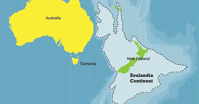
Zealandia is a nearly submerged continent in Oceania, largely submerged beneath the Pacific Ocean. It is the world's largest microcontinent, with a total area of approximately 4,900,000 km² (1,900,000 sq mi). Only 7% of Zealandia is above sea level, with New Zealand and New Caledonia being the largest landmasses.
 |
| Map of Zealandia |
The name and concept for Zealandia was proposed by Bruce Luyendyk in 1995. In 2017, a team of eleven geologists from New Zealand, New Caledonia and Australia concluded that Zealandia fulfills all the requirements to be considered a drowned continent, rather than a microcontinent or continental fragment.
Zealandia is a relatively new continent, having broken off from Antarctica about 100 million years ago and from Australia about 80 million years ago. It is also a very tectonically active region, with many faults and volcanoes.
The land mass may have been completely submerged about 23 million years ago, and most of it (93%) remains submerged beneath the Pacific Ocean. With a total area of approximately 4,920,000 km2 (1,900,000 sq mi), it is the world's largest current microcontinent, more than twice the size of the next-largest microcontinent and more than half the size of the Australian continent.
Zealandia is largely made up of two nearly parallel ridges, separated by a failed rift, where the rift breakup of the continent stops and becomes a filled graben. The ridges rise above the sea floor to heights of 1,000–1,500 m (3,300–4,900 ft), with few rocky islands rising above sea level.
The ridges are continental rock, but are lower in elevation than normal continents because their crust is thinner than usual, approximately 20 km (12 mi) thick, and consequently they do not float as high above the Earth's mantle.
 |
| Topographic map of Zealandia |
About 25 million years ago, the southern part of Zealandia (on the Pacific Plate) began to shift relative to the northern part (on the Indo-Australian Plate). The resulting displacement by approximately 500 km (310 mi) along the Alpine Fault is evident in geological maps.
Volcanism on Zealandia has also taken place repeatedly in various parts of the continental fragment before, during and after it rifted away from the supercontinent Gondwana. This volcanism is widespread across Zealandia but generally of low volume apart from the huge mid to late Miocene shield volcanoes that developed the Banks and Otago Peninsulas.


